Thursday, December 05, 2013
Sunday, December 01, 2013
Monday, August 05, 2013
![]() |
| Farms: Highlands New Guinea |
![]() |
| Agricultural fields Highlands New Guinea |
![]() |
| New Guinea Man |
Tuesday, April 09, 2013
Sunday, November 25, 2012
![]() |
| Lake Victoria, Lake Albert and the Head Waters of the Nile |
It is extremely unlikely that the overwhelming majority of people have heard about the explorer Diogenes who sometime in the first century C.E. was blown off course in the Indian ocean and ended up in the port of Rhapta on the African coast near, or at modernday Dars es-Salaam in modernday Tanzania.
Monday, March 21, 2011
Thursday, November 04, 2010
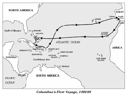
Christopher ColumbusOf course virtually everything in the above paragraph is myth. It was for example received educated opinion in Europe in Columbus’ time and had been so since the Greeks that the Earth was round.1 That particular myth I may look at at another time. Here I will look at the myth of Christopher Columbus as lone genius.
Supposedly the received view is that Columbus was a lone genius who had an idea that no-one had before. The idea being that one could reach Asia by sailing west. This is false as the following quotes from Admiral of the Ocean Sea, by Samuel Eliot Morison indicate.
Morison was to put it mildly a hero worshipper of Columbus, as indicated by his grossly apologetic way of dealing with the way Columbus dealt with native Americans, so his comments are of interest. For Example Morison says:
Also:Why not try sailing west, to Japan, China and India?
What would prevent it? No flat-earth theory certainly; for of all the vulgar errors connected with Columbus, the most persistent and the most absurd is that he had to convince people "the world was round." Every educated man in his day believed the world to be a sphere, every European university so taught geography, and seamen, though they might doubt the practical possibility of sailing "down under" or holding on when you got there, knew perfectly well from seeing ships "hull down" and raising mountains as they approached, that the surface of the globe was curved. Aristotle was reported to have written that you could cross the ocean from the Spains to the Indes paucis diebus, in comparatively few days; and Strabo, the Greek geographer who died about a.d. 25, hinted that it had actually been tried. "Those who have returned from an attempt to circumnavigate the earth do not say that they have been prevented from continuing their voyage by any opposing continent for the sea remained perfectly open, but through want of resolution and the scarcity of provision.”2
Interestingly enough this Columbus worshipper said in his The European Discovery of America: The Northern Voyages, Samuel Eliot Morison, Oxford University Press, New York, 1971, the following concerning L'Anse Aux Meadows, (this is c. 11 years after the discovery):Whilst no valid ground exists to question the traditional concept that Columbus's purpose was to reach Asia by sailing west, there is plenty of room for argument as to where he got the idea, and when..... Certainly the theory was not original with him. We have already seen what Aristotle was reputed to have said, and what Strabo did say, about the possibility of sailing west to the Orient. Since there was no doubt of the world being a sphere, almost everyone admitted that Columbus's theory was valid;...3
Finally in 1960, a Norwegian archaeologist named Helge Ingstad located a spot in northern Newfoundland, L'Anse aux Meadows, which he thought might be "it". Years of summertime diggings by competent archaelogists have (it seems to me beyond a reasonable doubt) proved this place to have indeed been Vinland, where Leif Ericsson spent one winter, and where members of his family founded a short-lived colony. So, now that the location of Vinland has been solved, we may proceed with the story told in the sagas.4
Just where did Christopher Columbus thought he was heading for? Some have asserted he knew that he was going to America. This seems to be rather unlikely given what the man wrote himself.
From the log-book of Christopher Columbus' first voyage. I note that Bartolome De la Casas,6 preserves Columbus' log in the form of a digest with extensive direct quotes, unfortunately the original is now lost. From the preamble:
The next material is from a letter of Columbus describing his first voyage and written on his return trip....your Highnesses decided to send me, Christopher Columbus, to see those parts of India and the princes and peoples of those lands and consider the best means of their conversion.7
Wednesday, 3 October
,...his {Columbus} purpose being to journey to the indies. He says that he would be foolish to delay.8
Saturday, 6 October
That night Martin Alonso said that it would be well to sail south-west by west, and the Admiral thought that he had the island of Cipangu {Japan} in mind, and saw that if they missed it they would not so easily come to the mainland and that the best thing would be to go there first and to the islands afterwards.9
Saturday, 13 October
But in order not to waste time I wish to go and see if I can strike the island of Chipangu.{Japan again slightly different spelling}10
Wednesday, 17 October
It has rained practically every day since I have been in those Indies.11
Sunday, 21 October
After this i shall set out for another island which, according to the indications given me by the Indians whom I have aboard, must be Chipangu.{Japan}12.
In passing I shall see the others that lie between and according to whether I find a quanity of gold or spices I shall decide what to do next. But I am determined to go to the city of Quinsay {in China}, to deliver your Highnesses' letters to the Grand Khan and request his answer which I shall bring back.13
Tuesday, 23 October
I should like to depart today for the island of Colba {Cuba}, which I believe according to the indications of its size and riches given us by these people must be Chipangu.{Japan}14
Wednesday, 24 October
...for if I am to believe the indications of all those Indians and those I have on board - I do not know their language - this is the island of Chipangu {Japan} of which marvelous tales are told, and which in the globes that I have seen and on the painted map of the world appears to lie in this region.15
Sunday, 28 October
The Admiral understood that the Gran Khan's {Title of the ruler of China} ships come there and that they are large and that the mainland is ten days' journey away.16
The next material is from a letter of Columbus describing his fourth voyage (1502-1504).When I reached Cuba, I followed its north coast westwards, and found it so extensive that I thought this must be the mainland, the province of Cathay.{China}17
In this island of Hispaniola I have taken possession of a large town which is most conveniently situated for the goldfields and for communications with the mainland both here, and there in the territory of the Grand Khan, with which there will be very profitable trade.18
The above make it quite clear where Columbus thought he was going. It is also clear that he still thought he was near Cathay (China) during his last voyage. Which is a little strange given that by this time some Europeans were talking about the Americas as not being Asia but a “New World”.They say that Ciguare is surrounded by water, and that ten days' journey away is the river Ganges. These lands seem to lie in the same relation to Veragua as Tortosa to Fuentarabia or Pisa to Venice.19
I arrived on 13 May at the province of Mago, which borders on Cathay {China}, and from there set out to Hispaniola.20
It is said that inland in the country lying towards Cathay {China} they have gold-embroidered materials.21
1. For more about this myth see Myth of the Flat Earth, Wikipedia Here.2. Morison, Samuel Eliot, Admiral of the Ocean Sea, Little Brown and Company, Boston, 1942, vol. 1, p. 45. Here are two fuller translations of the passage that Morison quotes part of:
8. Perception and experience alike inform us, that the earth we inhabit is an island: since wherever men have approached the termination of the land, the sea, which we designate ocean, has been met with: and reason assures us of the similarity of those places which our senses have not been permitted to survey. For in the east the land occupied by the Indians, and in the west by the Iberians and Maurusians, is wholly encompassed [by water], and so is the greater part on the south and north. And as to what remains as yet unexplored by us, because navigators, sailing from opposite points, have not hitherto fallen in with each other, it is not much, as any one may see who will compare the distances between those places with which we are already acquainted. Nor is it likely that the Atlantic Ocean is divided into two seas by narrow isthmuses so placed as to prevent circumnavigation: how much more probable that it is confluent and uninterrupted! Those who have returned from an attempt to circumnavigate the earth, do not say they have been prevented from continuing their voyage by any opposing continent, for the sea remained perfectly open, but through want of resolution, and the scarcity of provision.(Strabo, The Geography of Strabo, Book 1, Ch. 1, s. 8)
From Strabo, The Geography of Strabo, v. 1, The Macmillan Co., New York, 1903. Copy available from the Internet Archive Here.
8 We may learn both from the evidence of our senses and from experience that the inhabited world is an island; for wherever it has been possible for man to reach the limits of the earth, sea has been found, and this sea we call "Oceanus." And wherever we have not been able to learn by the evidence of our sense, there reason points the way. For example, as to the eastern (Indian) side of the inhabited earth, and the western (Iberian and Maurusian) side, one may sail wholly around them and continue the voyage for a considerable distance along the northern and southern regions; and as for the rest of the distance around the inhabited earth which has not been visited by us up to the present time (because of the fact that the navigators who sailed in opposite directions towards each other never met), it is not of very great extent, if we reckon from the parallel distances that have been traversed by us. It is unlikely that the Atlantic Ocean is divided into two seas, thus being separated by isthmuses so narrow and that prevent the circumnavigation; it is more likely that it is one confluent and continuous sea. For those who undertook circumnavigation, and turned back without having achieved their purpose, say that the they were made to turn back, not because of any continent that stood in their way and hindered their further advance, inasmuch as the sea still continued open as before, but because of their destitution and loneliness. (Strabo, The Geography of Strabo, Book 1, Ch.
1, s. 8)
From Strabo, The Geography of Strabo, available from LacusCurtius Here.
3. IBID, p. 78.
4. Morison, Samuel Eliot, The European Discovery of America: The Northern Voyages, Oxford University Press, New York, 1971, p. 38.
5. Columbus, Christopher, The Four Voyages of Christopher Columbus, Edited by J. M. Cohen, Penguin Books, London,1969.
6. Bartolome De la Casas, who became known as defender of the Indians, and is almost the perfect choice for becoming the patron Saint of human rights was a 15th-16th century monk who is also invaluable for editing and preserving many documents related to the European discovery of the Americas. Columbus; log of his first voyage being the most important.
7. Columbus, p. 37.
8. IBID, p. 49.
9. IBID, p. 50.
10. IBID, p. 57.
11. IBID, p. 67.
12. IBID, p. 71.
13. IBID, p. 71-72.
14. IBID, p. p. 72.
15. IBID, p. 73.
16. IBID, p. 76.
17. IBID, p. 115.
18. IBID, p. 120.
19. IBID, p. 288.
20. IBID, p. 294.
21. IBID, p. 298.
Pierre Cloutier
Wednesday, November 04, 2009
Some of the most amazing feats of exploration are very poorly known. For example it appears that the first circumnavigation of Africa was achieved some time during the reign of Pharaoh Necho II of the Saite dynasty, (610-595 B.C.E.).1 Herodotus describes the voyage as follows:
For it is clear that Libya [Africa] is surrounded by water except for where it borders Asia. The first one we know of to have discovered this fact was Nechos king of Egypt. After he had stopped excavation work on the canal, which extended from the Nile to the Arabian Gulf, he sent some Phoenicians off on boats with orders to sail around Libya and back through the Pillars of Herakles [Straits of Gibraltar] into the Mediterranean Sea and to return by that route to Egypt. And so the Phoenicians set out from the Erythraean Sea [Red Sea] and sailed the Southern Sea. Whenever autumn came, they would put in to shore at whatever region of Libya they happened to have reached in order to sow seeds. There they would wait for the harvest, and after reaping their crops, they would sail on again. This they did for two years, and in the third, they came around through the Pillars of Herakles and returned to Egypt. They mention something else which I do not find credible, though someone else may: that when they were sailing around Libya, the sun was on their right side as they went.2
Not surprisingly the above account has given rise to much discussion about whether or not it describes a real event. The consensus seems to be that it does for two main reasons.
First the amount of time given for the voyage, more than two years is realistic given the types of ships available and their limitations. Certainly the added detail of the crews stopping twice to sow crops also rings true. Secondly the detail that Herodotus records only to dismiss it as unbelievable, i.e., the sun being on their right is in fact true. This is true because in the Northern Hemisphere the sun if one is sailing westward the sun would always be on the left in the south. When one crosses the equator, the sun would appear overhead and then south of the equator the sun in the Southern Hemisphere would appear to the right in the north.3
It is in fact the second detail that is most convincing and it is rendered even more convincing in that Herodotus dismisses this as untrue. Apparently because he was unaware of the idea of the Earth having a spherical shape.4
Even in antiquity the above story was doubted by many. For example:
The Historian Polybius also expressed doubts:In giving the names of those who are said to have circumnavigated Libya Poseidonius says that Herodotus believes that certain men commissioned by Neco accomplished the circumnavigation of Libya; and adds that Heracleides of Pontus in one of his Dialogues makes a certain Magus who had come to the court of Gelo assert that he had circumnavigated Libya. And, after stating that these reports are unsupported by testimony,…5
Just as with regard to Asia and Africa where they meet in Aethiopia no one up to the present has been able to say with certainty whether the southern extension of them is continuous land or is bounded by a sea,…6
Finally the great polymath Ptolemy had Africa joined to Asia! For example see this map made from the coordinates given in Ptolemy’s book.7
Also the whether or not the voyage actually happened has been doubted up to today, for various reasons.
The lack of detail for example, even the name of the Commander is not given. The lack of detail is hardly surprising however given that at the time it is unlikely that much more than a summary report would have been deposited in any archive or that after c. 100 years there would be much recorded except a brief summary and oral reports.
Further in regards to Herodotus; he may have heard details and simply recorded a bare summary of what he heard. We do know that Herodotus did not record everything he heard.8
So it appears that the lack of detail such as a notification of the disappearance of the Great Bear constellation, etc., is not much of a problem, further why then not ignore the telling detail of the position of the sun?
In fact the lack of elaborate detail, and fanciful stories are powerful indicators that the story is likely true. It sounds relatively prosaic and the only detail that Herodotus gives that he considers fanciful is absolutely true! Further the argument that the Pharaoh Necho would never approve of such a speculative venture is completely speculative. The fact is we do not know enough about him to judge what was or was not within his character.9
As for problems such as if they could make the voyage if they lacked a compass? It should remembered that they were following a coast line. On the way south on their west side and on the way north on their east side. This is not all that difficult. Given that sea travel in those days tended to be coast hugging and not a huge amount of cross oceanic travel, and considering that this particular voyage being into the unknown would if anything tend to be even more coast hugging it is not likely that a compass would be necessary to do it at all.10
Some have alleged the voyage is to short. This can be dismissed without further ado. The voyage took over two years, plenty of time even with two stops to grow crops. The idea that the sailors from the Northern latitudes would not have been able to judge when to plant makes them singularly unobservant and they could also ask the locals.11
As for why such a voyage was not repeated at a later date if it was in fact done. It should be remembered that the evidence we have indicates that later attempts to circumnavigate Africa were through the Mediterranean and down the west coast of Africa. There the currents and winds, especially for the vessels used in antiquity made such an attempt very difficult. In fact the Portuguese when they attempted it had great difficulty, because of winds and currents near the African coast. In the end they found that sailing far out into the Atlantic and then at the latitude of the Cape of Good Hope sailing East was the best way to do it. For the ships of antiquity such a voyage was frankly suicidal!12
The following is a possible reconstruction of the voyage. They probably left in November from a Red Sea port, they would have sailed out of the Red sea and into the Indian Ocean. There the wind and current would sweep them south. Until the Mozambique current caught them and moved them even further south past the Cape of Good Hope. Near by they may have stopped and sowed and harvested some crops, perhaps in May. Circumstances along with their orders would have urged them north, since the currents and winds that eased their journey south would have made any return voyage back up the east coast of Africa in the ships they had extremely difficult.
After the harvest the winds and currents would have helped them north up to the great bend of Africa. Along the Guinea coast they would have encountered winds and currents that were hostile but they could get past those obstacles because they could use oars. Some time in November December they would have stopped in Morocco and sown more crops and after harvesting them returned through the Mediterranean to Egypt after a voyage of c. 2 ½ years!13 They must have been glad to get home.
Of course for both the Phoenicians and Nechos this trip served to tell them that going around Africa for trade or shifting ships was not practical at the time. It also was a feat of sailing that was not duplicated, that we know of, for c. 2000 years. It was simply not practical until the late 15th century.
It is however of interest that even that long ago men were trying out daring feats of exploration and discovery and that man thirst for knowledge is not a modern invention.
1. Herodotus, The Landmark Herodotus: The Histories, Random House Inc., New York, 2007, p. 297-298, Cary, M. & Warmington, E. H., The Ancient Explorers, Second Edition, Penguin Books, London, 1963, pp. 110-119, James, Peter, & Thorpe, Nick, Ancient Mysteries, Ballantine books, New York, 1999, pp. 368-369, Casson, Lionel, The Ancient Mariners, Minerva Press, New York, 1959, pp. 129-132, Morison, Samuel Eliot, The European Discovery of America: The Northern Voyages, Oxford University Press, 1971, p. 5, Rennell, James, The Geographical System of Herodotus, V. 2, Second Edition, C. J. G. & F. Rivington, London, 1830, pp. 348-408, at Internet Archive Here.
2. Herodotus, 2007, Book 4, s. 42. Some translations add “-to northward of them.” See Herodotus, The Histories, 2nd Revised Edition, Penguin Books, London, 2003, Book 4. s. 42.
3. Herodotus, 2007, p. 299, Footnote 4.42.4a, James, pp. 370-371, Cary, p. 115, Casson, pp. 131-132.
4. James, p. 370.
5. Strabo, Geography, Book 2, s. 4, at LacusCurtius, Here.
6. Polybius, The Histories, Book 3, s. 38, at Lacus Curtius, Here.
7. See also Ptolemy, The Geography, Book 4, at Internet Archive, Here.
8. Lateiner, Donald, The Historical Method of Herodotus, University of Toronto Press, Toronto, 1989, pp. 59-75, Cary, pp. 114-115.
9. Cary, p. 115, Casson, pp. 131-132, James, pp. 369-373.
10. Cary, 115-116. James, IBID.
11. Cary, pp. 116-117, Casson, pp. 131-132.
12. Cary, pp. 117-118, Morison, Samuel Eliot, The European Discovery of America: The Southern Voyages, Oxford University Press, 1974, pp. 220-223, James, p. 374, Rennell, pp. 348-408.
13. Cary, pp. 117-119, James, p. 374, Casson, 131-132, Rennell, pp. 348-408.
Pierre Cloutier
Thursday, September 10, 2009
An Addition
In one of his postings Russell Potter discusses a collection of papers found by McClintock on a skeleton he found on the south coast of King William island in 1859.1
One of the documents was a summary of Harry Peglar’s navy service and it goes as follows:
November 1825
This is to Se( ) H Peglar Has served On board of his M S Clio 1825 Joined H M Ship Magnificent at Spit Head Sail For Jamaker Under Command Lev( )tenent Mundel tern Over to H M Hulk Serreapes Commander Ellott Tran( ) H M Ship Rattelsnake Captain J. Leath Searved Under him two years Joined H M tender Pearsis Captain C….t late Chief Press Master tower Hill London joined H M Ship Prince Regent discharged for ( )g apprentice Sail under Command of Tommy larking to China left Gor Tallis and his lady and douthers at ( )aint Helena Struck with lighting on the Passadge …ut tow Men Struck Dead a Seargent and Private Retern to England 182( ) entered for H M Ship Ramelis tern over at Chatham Reentered for The Tallavarer Cap Coalby Supper Seaed by Cap Brown Rit for my discharge and got … China in the Marquis Camden lost our Chief Mate Shot going in to Bombay Mr …en Retern to England 1833 …… H M Ship Gannett C M Maxfeild ( )ntered for H M Spih Temmarare 1838 ( )n over to H M Ship ocean Cp Sir John Hill Shearness Paid of 38 Joined H M S Wander…. C M Denman alas Seamour now in the Terror.3
The C The C the open C it grew so fresh the Ever free.….
When I wos On Old England Shore I like the/young C more and more and ofte times flewe/to a Sheetering Plase like a bird thar Seek it/mother’s Case and a H She wos and Oft to me/for I love I love a young and Hopen C.4
Remnants of tent foundation erected by members of the Franklin Expedition
Another document is the following address, “Mr. John Cowper, No 47 John St., Commercial Road, London. Paid.”6
Another document simply bears the words “ Sentemental Song”.7
Another document is largely indecipherable; it has a date “September … 1840” or “1846”. According to Cyriax and Jones it appears to be a story about a dog. There is a heading on this document saying “Lines writ on the north” and a drawing of a eye with the words “lid Bay” below it.8
Another document which seems to be about sea animals as part of it is as follows:
Late on one summers night/ … the month of june/ … sent a way/… a spoon/ Imaid my bark a thort the tide/ and my crew they went to sleep/ while…keep a lookout/ for fish alli n the deep/ Has my little bark was drifting down/ I wos shot a … and ggit one of O”Connell/ Tertill came swimming sloley by/ my crew got up and grapple him/ and lug him in my boat/ off one pull quite marely/ to that gallnt bark a float/ sir the wait … that little marter/ bird w…67 pounds/ the … made a splened/ hot dinner off … prime little fellow wot …/ a tertill.9
A little below that is written “Lines upon Trinadad laying in Asham Bay”.10
On another piece of paper is written “Lines writ … party wot happened at Trinadad”, and the word “September”, with some other words that could not be made out.11
Another document seems to be a sort of a poem. Cyriax and Jones give only the opening line stating that much is unintelligible. The line is:
O death whare is thy sting, the grave at Comfort Cove for who has any doubt how … the dyer sad and whare traffalger, etc.12
Considering what happened to the crews of the Erebus and Terror just a little to appropriate.
On the other side of this paper, written in a circle, are the following lines. “He I … ave wonder … mony a night gl … a bouat the harmonic”. Within that circle is written “ … rode … tell the w … you peglar bord onn hay the terror camp clear”.13
A further document seems to a description of gathering in Cumana Venezuela. Cyriax and Jones do not give a transcription of the text but it does include the following passage:
Has we have got some very hard ground to heave … we shall want some grog to wet houer … issel … all my art Tom for I do think … time … I cloze should lay and … the 21st night a gread.14
Cyriax and Jones wonder if the 21st mentioned is the 21st of April 1848 the day before the Terror and Erebus where abandoned by the surviving crew members.
On the back of the paper is the following address “IME…P Evarglleb Raauqs, Ocilmip, West”.15
Another paper as the following address, “O. J. Rezzoe, a Squier, R.N. … Sandile Harber … Belvue Couart … eth”16
Finally another piece of paper with another address, “To Mr. Heather, sen … Citty…ation, Abberdeen, Lond…”
There was also a parchment certificate of the seaman service of Harry Peglar. Cyriax and Jones do not provide a transcription and the writing appears to be largely illegible anyway.17
Infuriatingly the documents tell us next to nothing about what happened to the Franklin Expedition and from their fragmentary condition it appears that a good deal was lost of them during the attempted escape. It appears that the papers we have are documents by Peglar and one or more other men. Thus what we seem to have is a collection of what amounts to fragments written for the most part, for unknown reasons, backwards.
Still they are glimpse into the minds of those doomed men and it would seem that in fairness to their memory perhaps a full transcription of what can be gleaned from the papers, using modern methods of analyzing old documents to see if we can find more writing in the papers, should be published. So we can have a glimpse, however, fleeting of those lost lives.
1. Visions of the North, Here the posting about the Peglar papers Here
2. Cyriax, R. J., & Jones, A. G. E., The Papers in the Possession of Harry Peglar, Captain of the Foretop, H.M.S. Terror, 1845, The Mariner’s Mirror, v. 40, pp. 186-195, 1954.
3. IBID. p. 189.
4. IBID. p. 190.
5. IBID. p. 191.
6. IBID. p. 191.
7. IBID. p. 192.
8. IBID.
9. IBID.
10. IBID.
11. IBID.
12. IBID.
13. IBID. p. 192-193.
14. IBID. p. 193.
15. IBID. p. 193.
16. IBID. p. 193.
17. IBID. p. 188.
Pierre Cloutier
Monday, August 10, 2009
The Franklin Expedition, 1845-1848, was without a doubt the greatest Arctic exploration disaster in which every last member of the expedition perished.1 A great deal has been written and will continue to be written about the expedition and why it ended in disaster. There has also been not surprisingly been a great deal of, what can only be described, has fantasy.2
The key document, and in fact the only document found, concerning the fate of the expedition, (aside from graves on Beechey island with headboards3), was a document found buried in a cairn at Victory Point on the north west side of Kings William island.
The first note bears the date of May 28, 1847 and says:
28 of May, 1847 (H. M. ships Erebus and Terror wintered in the ice in lat. 70 05’ N. long. 98 23’ W.) Having wintered in 1846-7 at Beechey Island, in lat. 74 43’ 28” N., long. 91 39’ 15” W., after having ascended Wellington Channel to lat. 77, and returned by the west side of Cornwallis Island. Sir John Franklin commanding the expedition. All well. Party consisting of 2 officers and 6 men left the ships on Monday 24th May, 1847.
Gm. Gore, Lieut.
Chas. F. Des Voeux, Mate.5
April 25, 1848. H. M. ships Terror and Erebus were deserted on the 22nd April, 5 leagues N.N.W. of this, having been beset since 12th September, 1846. The officers and crews, consisting of 105 souls, under the command of Captain F. R. M. Crozier, landed herein lat. 69 37’ 42” N., long. 98 41’ W. Sir John Franklin died on the 11th June, 1847 and the total loss by deaths in the expedition has been to this date 9 officers and 15 men.
F. R. M. Crozier cccccccccccJames Fitzjames
Captain & Senior Officer. cccCaptain H. M. S. Erebusand start (on) to-morrow, 26th, for Back s Fish River.6
Lieutenant Graham Gore and Mr. Charles F. des Voeux, mate, left the ships on Monday, the 24th of May, 1847, with six men. H.M. ships Erebus and Terror wintered in the ice in latitude 70 5' N, longitude 98 23' W. Having wintered in 1846-47 at Beechey island in latitude 74 43' 28" N., longitude 91 31' 15" W. After having ascended Wellington channel to latitude 77, returned by the west side of Cornwallis island, (Sir) John Franklin commanding the expedition. All well.7
(1)848. H.M. ships Terror and Erebus were deserted on the 22nd April, 5 leagues .N. W. of this (hav)-ing been beset since 12th Sept., 1846. The officers & crews consisting of 105 souls under the command ---tain F R M. Crozier landed here in lat. 69 37' 42", long. 98 41' paper was found by Lt. Irving under the cairn supposed to have been built by Sir James Ross in 1831, 4 miles to the northward, where it had been deposited by the late Commander Gore in June, 1847. Sir James Ross' pillar has not, however, been found, add the paper has been transferred to this position which is that in which Sir J. Ross' pillar was erected. Sir John Franklin died on the 11th June, 1847, and the total loss by deaths in the expedition has been to this date 9 officers & 15 men.
F. R. M. CroziercccccccccccJames Fitzjames
Captain & Senior Officer cccCaptain H. M. S. Erebusand start on to-morrow 26th, for Back's Fish river8.
What can we say from this single and singularly laconic document? Well we can say a few things concerning the fate of the expedition.
1, The expedition circled Cornwallis island in 1845 (see map) and then wintered at Beechey island. Where from the graves we know three men died, that winter of 1845-1846.
2. In 1846 the expedition sailed south probably through Peel sound and was beset by the ice on 12th September 1846.
3. On the 24th of May 1847 a 8 man expedition led by Lieutenant Gore left the ships and buried an Admiralty paper and on which, dated the 28th of May 1847 was written certain details about the expedition.
4. Shortly after on June 11, 1847 John Franklin died.
6. On April 22, 1848 the ships were abandoned.
7. On April 25, 1848 the New Commander Crozier left a note indicating when Franklin had died and that there were 105 men left. Nine officers, including Lieutenant Gore, and 15 enlisted men had died so far. From the note we learn that the remnants of the expedition will try to go up the Back river apparently to reach the Hudson Bay posts around Great Slave Lake.
8. If we exclude the 3 men who died at Beechey island it appears that 21 men had died in the two winters beset off the coast of King William island.
Aside from the above everything else is sheer conjecture. I will however point out to those who argue that the phrasing in the message does not necessarily mean that the ships were completely abandoned and everything was bet on an all or nothing race up the Back river that the text clearly says the ships were deserted and that all 105 of the survivors had landed. The text seems to be pretty clear that everyone was out of the ships and a make it or break it effort was going to be made for safety. Of course you could by semantic parsing and double talk say the text does not mean what it most likely means but without really good evidence I do not see any reason to doubt that the ships were completely abandoned and the last 105 men made a break for it.
The death total is significant in indicating how desperate things were. The note of May 28th 1847 does not indicate the death total so we can probably conclude that the number of deaths over the winter of 1846 / 47 were no worst than the number at Beechey island or perhaps no deaths at all. It seems likely the note would have mentioned anything unusual in that regard if it had happened. However it seems that the winter of 1847-48 had seen more than 10% of the crews dying. Perhaps as many as 21 men out of 126. This is a very high percent and would indicate that the health of the crew was bluntly quite poor. This would reinforce the idea that leaving the ships was an attempt to escape and that the crew was in truly desperate straits. All of this would seem to preclude the crews surviving very long unless they could get good food etc., very quickly. The time of year they left would not be conducive to finding food, as both Caribou and birds would not arrive until much later. Again a sign of desperation.9
A truly unlikely idea is that mistakes has to two dates in the document, (i.e., the statement about having wintered 1846-47 at Beechey island in the first note and the crossing out of May and replacing it with June, apparently done in April 1848, as the date in the note was first left in the carin in 1847) are errors that indicates lead poisoning can be dismissed as unlikely. I merely note that the first seems to be a “typo” of some kind, the second could be the same thing or may refer to another event regarding the note, it is of interest that the May added by Crozier in another part of the document which refers to Gore's time off the ship in 1847 is correct so the crossing out is mysterious but as indicated all the other dates including the dates given in the 1848 note, when they would have been even more lead poisoned, seem to be entirely correct. It is likely that stressed desperate men would make mistakes of this kind without lead poisoning or they could simp-ly be the result of "typos" drawing far ranging inferences from these errors seems dubious.10
I further note that given the dates given in the second note for abandoning the ships and the date the note was written it appears that it took three days for the crews to drag themselves to King William island, which would certainly not indicate a thoroughly fit crew. Given the deaths recorded already it is likely the crew was in overall bad shape and the exertions of dragging heavy sleds and boats, to say nothing of an assortment of useless crap, being ill equipped for the weather and poorly nourished make it very likely that all of Franklin’s men perished in a few months. It’s possible that a few survived longer but that only remains a possibility.11
Much as been written about what happened to the Franklin expedition and why. It seems to be the case that if some of Franklin’s men had been able to live and forage in the polar environment they would have had a better chance of survival. Although it must be emphasized that the sheer size of the Franklin expedition, 129 men, would have made it very difficult for them to survive in such a resource poor part of the Arctic as King William island.12
In the end this very short laconic document provides a revealing glimpse into over 100 men sliding into a hell on earth and then death. Perhaps we should learn from it to cherish life and each other more.
1. M’Clintock, Francis, In the Arctic Seas, Porter and Coates, Philadelphia, 1859, p. 317. A copy can be found at Internet Archive , Here.
2. for responsible books that describe the Franklin expedition in detail see Berton, Pierre, The Arctic Grail, Anchor, Books, Toronto, 2001 and Beattie, Owen, Geiger, John, Frozen in Time, 3rd Edition, Greystone Books, Toronto, 2004. For irresponsible books see Latta, Jeffery Blair, The Franklin Conspiracy, Hounslow Press, Toronto, 2001, Woodman, David C., Unravelling The Franklin Mystery, McGill-Queen's University Press, Montreal, 1991.*
3. See Beattie. The inscriptions on the headboards read as follows:
Sacred to the memory of John Torrington, who departed this life January 1st, A.D.1846, on board of HM ship Terror, aged 20 years
Sacred to the memory of John Hartnell, AB, of HMS Erebus, died January 4th, 1846, aged twenty-five years. “Thus saith the Lord of Hosts, consider your ways.” Haggai, I, 7
Sacred to the memory of William Braine, RM of HMS Erebus, died April 3rd, 1846, aged thirty-two years. “Choose ye this day whom you will serve”, Joshua xxiv, 15
The source for the inscriptions is Battersby, William Hidden Tracks, at Here.
4. Cyriax, Richard J., Sir John Franklin's Last Arctic Expedition, Methuen & Co. LTD., London, 1939, pp. 128-131.
5. M’Clintock, p. 256.
6. IBID. p. 258.
7. Low, A. P., Dominion Government Expedition to Hudson Bay and the Arctic Islands, Government Printing Bureau, Ottawa, 1906, p. 97. A copy can be found at the Internet Archive Here.
8. Low, pp. 97-98.
9. See Berton, pp. 334-341.
10. See Beattie for more. I note here that I do not dispute that Franklin’s crews suffered from Lead poisoning or that this contributed to the disaster; if only by lowering the crew’s resistance to other diseases and deficiencies. What I dispute is the idea that this lead poisoning led to a massive amount of disordered thinking by the crew that contributed to the disaster. In other words their minds were befuddled by lead and they could not think clearly. Well these two notes, if anything, indicate clear thinking and a lack of befuddlement. That of course does not mean they made the right decisions just that it appears that their thinking processes were not seriously impaired by lead.
11. Berton, pp. 331-332, M’Clintock, pp. 262-271. For a analysis of the tragedy that heavily emphasizes how unprepared Franklin's crews were to survive in the Arctic if something went wrong see Stefansson, Vilhjalmer, Unsolved Mysteries of the Arctic, Macmillian Company, New York, 1939, pp. 36-129.
12. Berton, pp. 335-341, Stefansson.
* The reason why I include David C. Woodman’s book and by implication his other books about the Franklin expedition is his cavalier attitude towards Inuit testimony. He insists on interpreting all sorts of Inuit testimony about European explorers in the region of King Williams island as memories of the Franklin expedition despite the fact that before and after the expedition there was all sorts of European explorers who visited the area, for example in the years 1854-59. When a lot of this testimony was collected beginning in the late 1860’s and continuing to past 1900 there were lots of European explorers who had visited the area after Franklin to say nothing of before Franklin. It was not the Inuit who described those expeditions as Franklin’s but the Europeans. The Inuit were actually very honest, but like most oral peoples their memory for exact dates of events more than a generation before being recorded is a not exact. Further all the stories that Woodman uses to indicate a late abandonment of the ships possible survival etc., is almost entirely of late derivation and likely attributing such testimony to describing the Franklin expedition rather than earlier or later ones shows wishful thinking on the part of the European collectors of such testimony, not any error on the part of the Inuit. The testimony most germane to the destruction of the Franklin expedition was collected by Rae, M’Clintock and others in the period 1853-1860 and it would appear to indicate that the entire expedition perished soon after abandoning the ships in the spring of 1848.
Pierre Cloutier